016 - 13th June 2024
Its a crazy time of the year with EOFY and getting all those projects in! Find out below about how geologists helped out with D-Day, Denmark’s User group Facebook and the QGIS Open Day is approaching. We want your ideas and your involvement in planning for the QGIS AU User Conference and FOSS4G SotM Oceania.
EVENTS #
- QGIS Open Day 28th June
- Brisbane Geospatial Network 1st Wednesday of the Month
- Brisbane GeoRabble 9th July, Charming Squire
- QGIS User Conference, Bratislava, Slovakia: 9-10th September
- 2024 QGIS AU User Conference, Hobart: 4th November
- FOSS4G SotM Oceania 2024 Hobart: 5-8th November
- Everything Open 2025, Adelaide: 20-22 January 2025
- 2025 QGIS AU User Conference, Norrköping Sweden: early June
- **2025 FOSS4G Conference, Auckland Aetearoa New Zealand: November
Check the Events page for more information.
QGIS AU News #
Workshops and hackathon ideas are needed for QGIS AU User Conference and the FOSS4G SotM Oceania Conference. If you would like to be involved in presenting the QGIS AU events, let us know via the email list.
QGIS Project News #
- Check out our friends from QGIS Denmark User group Facebook site.
- QGIS Open day is coming up on the 28th June - got something to present?
Maps and D-Day #
Read this interesting paper on the role of Geologists in D-Day. Like blockbuster movies where the actors get all the accolade, here, the geologist (and cartographers) are but treated like the production crew - the unsung heroes. It bounces around with amazing stories on map numbering, sorucing the data and the images provided are great. This one shows the legend matrix for assessing land to put airfields.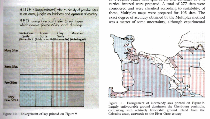
Hints and Tips #
- Geoscience Australia’s Australian Exposure Information Platform (AEIP) to create an exposure report based on themes including agriculture, buildings or environment and where you can pick the hazard and the extent. This then gets emailed to you with a shp, png, excel and geojson.
- Python Color Palette Finder 2500+ palettes whilst for matplotlib/seaborn - still a great resource for curated palettes when you are need help picking colours.
Emergency Mapping #
- PNG Landslide
- Kanlaon Volcano eruption in the Philipines
- Rio Grande du Sul floods in Brazil
Check out the HOTOSM Tasking Manager to get started.
Newsletter Content #
Finding these emails boring and want to contribute some content? You can provide an interest story, a report on an event or a technical instruction. Head to the Content Contrbution form to fill in your contribution. We will then contact you to run through the contribution.