QGIS Australia webinar: Urban Development Modelling and Australian GIS Datasets - save the date!
QGIS Australia are following up their popular first webinar with July’s deep dive into Urban Development Modelling and Australian GIS Data Sources. This will be approximately 1 hour duration with the details below. Please be sure to mark this in your calendar and distribute this to your network to ensure the word gets out.
Date: 16 July 2026
Time: Please note time-zones below
WA: 11am
SA-NT: 12.30pm
AEST: 1pm
NZ: 3pm
Meeting Link: https://meet.google.com/fwi-wqyp-vic (updated 18/06/2026)
To subscribe to the QGIS Australia YouTube channel and view recordings: https://www.youtube.com/@QGISAustralia
Programme Overview
- Introductions John Bryant
- Urban Development Modelling in QGIS using QCity Gabriel Diosan
- Discovering Australian GIS data sources Colin Mazengarb
Presentations
Urban Development Modelling in QGIS using QCity - Gabriel Diosan
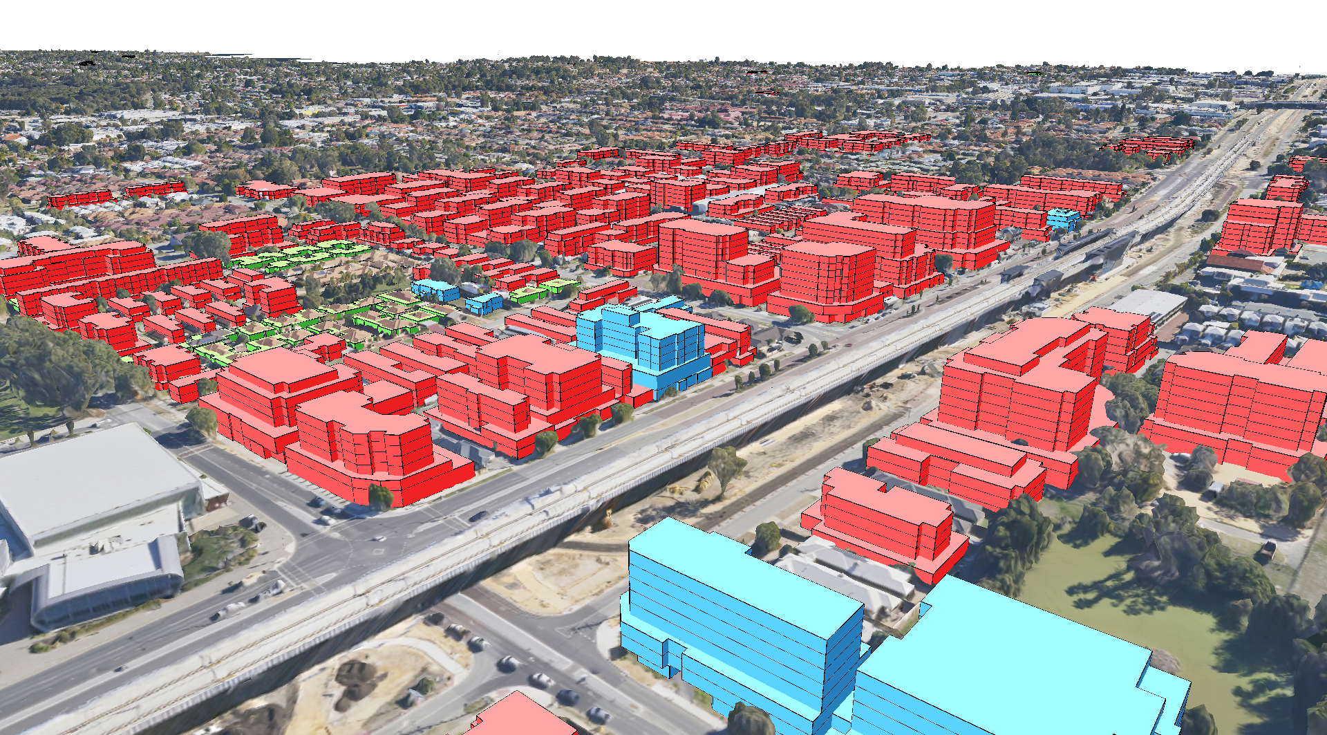
Urban planners increasingly need data to make decisions. When planning for a project area, there is a need to understand the outcome of the planning framework. This includes information such as the dwelling yield, floorspace yield and parking provision within the project area. In this presentation, I will explore the use of QGIS for modelling development sites to ascertain dwelling yield over a project area and how this resulted in a multi-year project to develop QCity, the urban development modelling plugin for QGIS. I will also cover City of Canning funded development in the QGIS model designer, which allows for more streamlined analysis of QCity data.
About Gabriel
Gabriel Diosan is the Senior Strategic Planning Spatial Analyst at the City of Canning in Western Australia. He has successfully managed, on behalf of the City of Canning, many feature enehancements in QGIS since 2019.
Discovering Australian GIS data sources - Colin Mazengarb
This talk will be an exploration of where and how to find data in Australia, a task that is very broad and challenging. As such this talk will be a starting point as the sources are spread widely. Each jurisdiction may have multiple agencies and councils, as well federal government departments. Multiply them all together and the number explodes. Then there are the private sources!
I will explore QGIS plugins and links to various agencies where more than the occasional broken link exists! Lastly I will demonstrate how to extract web service URLs from web map browsers and government websites.

About Colin
Colin has worked in the fields of regional geology and engineering-geology in government organisations in NZ, Australia and the USA over a 40-year career. He began his GIS journey over 30 years ago using Arcview 2 (some of you may remember this and the Avenue programming language!) and successive software to undertake geological mapping and natural hazard analysis. In the last 10 years he has developed courses for the geotechnical community to transition practitioners into GIS using the QGIS platform. He 'retired' in 2003 but continues to run his courses regularly in Australia and NZ and is involved in a NZ research project addressing landscape evolution and landuse issues in a highly eroding catchment. He is also one of the current 'coordinators' of QGIS Australia..
We look forward to meeting you all.